The shape and the gravity field of the Earth vary in time. Geodetic techiques are able to detect those subtle changes using measurements on board of satellite platforms (radar altimetry and gravimetry missions), ground based observations (tide gauges, gravimeters) or both (Global Navigation Satellite System - GNSS). Such observations contain precious information about the changes in the Earth's mass distribution from its most external enveloppes to its core. In particular, key parameters about the water cycle, sea level variations and crustal deformations can be obtained.
Detection of a 6-year cycle in the Earth's system
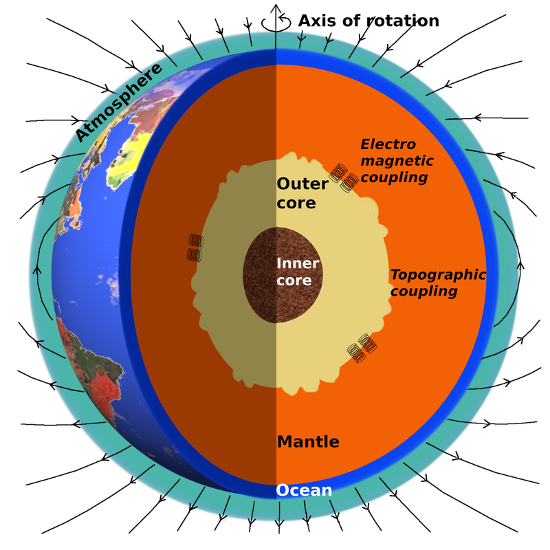
Schematic representation of the different layers of the Earth system, from the solid inner core to the atmosphere, and of the coupling mechanisms at the outer core–mantle boundary. The thin black curves around the Earth represent the magnetic field lines. Taken from Cazenave et al., (2023).
|
The GRACEFUL project aims at better understanding dynamical processes originating in the Earth's core using a synergy of satellite observations of the magnetic field, gravity field and rotation.
Fast core flow, expressed as torsional waves or quasi-geostrophic magneto-coriolis modes, generate changes in the magnetic field and the Earth's rotation at a recurring 6-year period. We discovered recently that the atmosphere rotates together with the solid Earth at a period of 6 years. In an even more surprising way, we discovered many oscillations at a 6-year period in the climate system, impacting zonal winds, temperature, precipitation, mean sea level, ocean heat content, ice mass changes over Greenland and continental glaciers, as well as continental freshwater storage. These observations suggest that internal and external geodynamics might be linked at a 6-year period. One explanation might be that dynamical processes originating in the Earth's core induce a rotation not only of the solid Earth, but of the solid Earth and the atmosphere together, as a gravitationally coupled system. Changes in the rotation rate of the atmosphere would in turn impact the atmospheric circulation and by cascade the Earth's climate. Publications:
|
Identification of climate modes in satellite gravimetry measurements
|
Climate modes are emergent features of the climate system, setting the rhythm of precipitations, sea surface temperature, wind speed or air pressure. The El Niño–Southern Oscillation (ENSO) is one of the most well-known, as it is frequently associated with extreme climate events such as catastrophic floods (e.g. 1997-1998 winter in Florida) or droughts (e.g. 2019-2020 Australian black summer) in various regions of the world.
This study reviews the impact of eight major climate modes on the global water cycle measured with the GRACE and GRACE-FO satellite gravity missions. For the first time, we were able to track the interactions between these modes in distinct water reservoirs such as the oceans, the main river basins and ground-based glaciers, located in Greenland and Antarctic ice-sheets and in mountainous regions of the world. We were able to quantify the contributions of climate modes to the inter-annual variability of the global water cycle, which will be important to understand and predict climate extremes, but also to unveil weaker signals related to climate change or other geophysical processes. Publication: Pfeffer, J., Cazenave, A., & Barnoud, A. (2021). Analysis of the interannual variability in satellite gravity solutions: detection of climate modes in water mass displacements across continents and oceans. Accepted for publication in Climate Dynamics. https://doi.org/10.21203/rs.3.rs-177716/v1 |
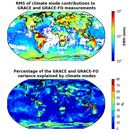
Amplitude of interannual water mass changes due to a combination of eight climate modes in satellite gravity measurements. The time-series used to estimate the total water mass distributions come from the average of three mascon solutions (JPL, CSR, GSFC). The seasonal terms and secular trends have been removed from the average GRACE time-series, to focus on interannual signals.
|
Non-closure of the global mean sea level budget
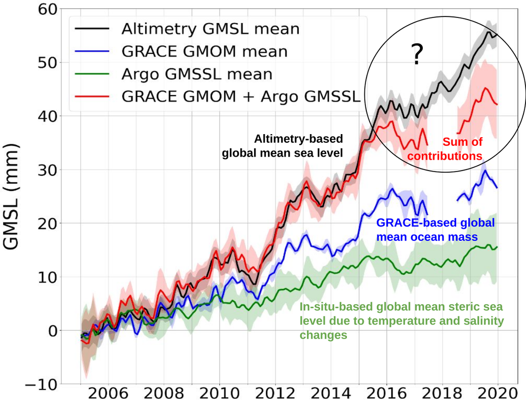
Assessment of the global mean sea level budget closure
Publication: Barnoud, A., Pfeffer, J., Guérou, A., Frery, M.-L., Siméon, M., Cazenave, A., et al. (2021). Contributions of altimetry and Argo to non-closure of the global mean sea level budget since 2016. Geophysical Research Letters, 48, e2021GL092824. https://doi.org/10.1029/2021GL092824 |
Because of global warming, the sea level has been rising at an accelerated rate over the past decades. The global mean sea level (GMSL) rise is mainly due to the melt of glaciers and ice-sheets (leading to an increase in the global mean ocean mass, i.e. GMOM) and to the thermal expansion of the ocean (leading to an increase in the global mean steric sea level, i.e. GMSSL). These three component are routinely measured with satellite altimetry (GMSL) and gravimetry (GMOM) missions, and the deployment of in-situ temperature and salinity sensors (i.e. the Argo float measuring the GMSSL).
Closing the sea level budget (i.e. ensuring that the sum of contributions adds up to the total; GMSL = GMOM + GMSSL) is important to monitor the health of our observing system. However, beyond 2016, the GMSL budget appears no longer closed. In this study, we review all potential contributions that could explain this gap. We find that, drifts in salinity sensors explain up to 40% of the misclosure. The remaining errors may be due to drifts in the altimetry measuring system (especially the radiometer used to estimate the wet tropospheric correction onboard Jason-3) or to instrumental issues (loss of accelerometers, gap between two missions) affecting the satellite gravimetry missions (GRACE and GRACE Follow On). Further studies are still needed to fully close the GMSL budget. |
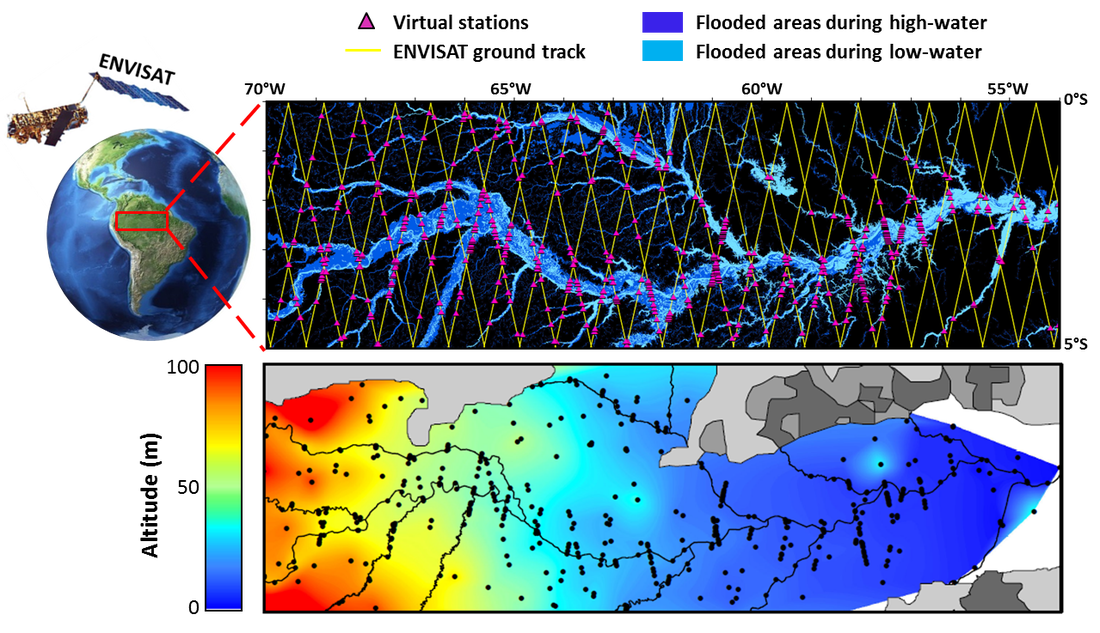
Insights on the Amazon groundwater resources from space
|
Groundwater plays a fundamental role in rainforest environments, as it is connected with rivers lakes, and wetlands, and helps to support wildlife habitat during dry periods. Groundwater fluctuations remain however poorly known in the Amazon River Basin due to the lack of in situ observations. Remote sensing observations provide a unique alternative to monitor water reservoirs across large and remote river basins.
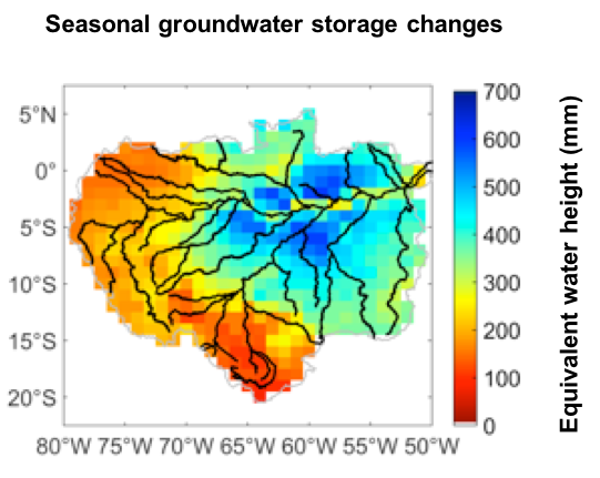
The total water storage changes monitored by GRACE (Gravity Recovery And Climate Experiment) satellites are divided into surface, soil and groundwater components, using multi-satellite data (satellite radar altimetry and microwave imagery) to constrain the changes in rivers, lakes and floodplains and hydrological models (WaterGAP) to predict soil moisture. Unprecedented information is derived from this combination of satellite observations and hydrological model outputs, allowing to track groundwater fluctuations from 2003 to 2010. Groundwater storage is shown to account for about one third of the total water storage changes on seasonal time scales and display strong interannual variability, especially along the central Amazon corridor, where the equivalent water height dropped by several tens of centimetres during the 2005 drought. |
|
Assessing the performance of historical reconstructions of the ocean temperature
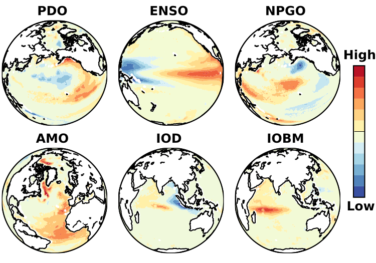
Typical fingerprints of six climate modes (PDO, ENSO, NPGO, AMO, IOD, IOBM) recovered in an ocean reanalysis (ORAS4), coupling in situ measurements of the ocean temperature and salinity (EN4) and satellite observations of the ocean state (e.g. altimetry) with an ocean model (NEMO)
|
In situ measurements collected from ships and floats show that the oceans have been warming during the 20th century. As the seawater warms, it expands and the sea level rises. Because of the ocean circulation and interactions with the atmosphere, the heat and salt are redistributed within the ocean basins, causing sea level to rise at very different rates in different regions of the world. Predicting these rates is extremely challenging because there are not enough observations to entirely cover the ocean basins.
We investigate here the ability of three different techniques to accommodate data gaps and reconstruct the ocean temperature and salinity since the 1950s. Based on the analysis of climate modes (i.e. typical patterns of the internal variability of the coupled atmosphere-ocean system), we show that assimilating in situ observations with ocean models provides the richer set of information at inter-annual and multidecadal time scales. Despite the short records available (~15 years), satellite observations reveal critical features of the sea level variability, that cannot be accessed by more traditional techniques based on the statistical analysis of in situ measurements alone. Such progress will increase confidence in the historical reconstructions of the ocean temperature and salinity, which is necessary to improve the closure of sea level budgets and validate future predictions of climate models. |
Understanding the causes of coastal vertical displacements
|
In coastal areas, vertical land motions result from a complex mix of geophysical processes driven by natural and anthropogenic factors. This study review the causes of vertical displacements observed at tide gauges and coastal GPS stations since 1993. The effects of glacial isostatic adjustment predict the major part of large scale (> 300 km) vertical displacements. Residual vertical displacements are shown to be particularly significant over nine well instrumented regions of the world. Significant activity occurs in these regions due to the earthquake cycle (Japan, South East Asia, region of the San Andreas Fault), fluid withdrawal (Japan, California, Southeast Asia), coal mine exploitation (Great Britain), volcanic charges (Hawaii), sediment loading (Gulf of Mexico) and tectonic forces (Northeast Mediterranean basin, Alaska). The local to regional vertical displacements expected from these processes range from 1 to 10 mm/yr. Coastal subsidence may even reach 100 mm/yr in densely populated areas, due to sediment shortage and compaction caused by fluid withdrawal, dam building and urbanization.
|
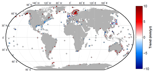
Vertical displacements observed at coasts from January 1993 to July 2013.
|
Sea Level Changes and Crustal Deformation in coastal areas
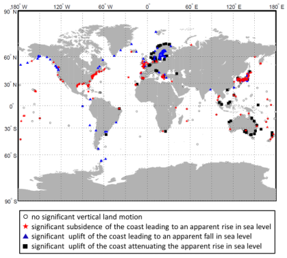
Contribution of vertical land motions to coastal sea level variations.
After Pfeffer & Allemand, 2016.
|
During my postdoc with the CNES, I developed the ALTIGAPS database. ALTIGAPS combines multisatellite altimetry, tide gauge and GPS data acquired in coastal areas over the past 20 years Vertical land motions and sea level variations are estimated simultaneously for a network of 886 ground stations with median errors around 1 mm/yr. ALTIGAPS present significant interest both by improved technical characteristics and by the novelty of the applications empowered. Here, the contribution of vertical land motions to relative sea level variations is explored to better understand the natural hazards associated with sea level rise in coastal areas. We show that the role of the crust is highly heterogeneous, as it can amplify, restrict or counter the effects of climate-induced sea level change. In particular, a set of 182 potential vulnerable localities are identified by large coastal subsidence which increases by several times the effects of sea level rise. See publication. See database. |
Groundwater maps from spatial altimetry
|
During my postdoc in Toulouse, I developed an original method for studying groundwater based on altitude measurements taken by satellite altimetry. I created the first maps showing the height of the Amazonian aquifer during the driest period of the year from 2003 to 2008. The maps evidence the response of the groundwater to droughts and will help better characterize its role in the climate and the Amazon ecosystem.
See publication. Outreach: |
Surface and groundwater maps in Central Amazon,
after Pfeffer et al., 2014
|
Seasonal water storage from ground gravity measurements
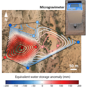
After Pfeffer et al., 2013
|
The aim of my PhD was to confront geodetic and hydrological measurements to bring new constraints on the water cycle in Sahelian Africa. I managed several field campaigns in south West Niger, in order to better characterize the properties and dynamic of the water storage at local scale. Absolute and relative gravity measurements turned out complementary and enabled to detect the main hydrological signatures related to the aquifer and the vadose zone. Absolute gravity measurements were employed to determine the drainage porosity of the underlying aquifer (see publication), whereas microgravimetry measurements allow imaging the water storage variations taking place between the surface and the aquifer at small time and length scales (see publication). |
Hydrological loading from GRACE satellites
|
In addition to the Newtonian attraction of water masses, the water acts as a load and induces a deformation of the Earth’s crust due to its elastic behaviour. The sum of these effects results in non-negligible changes in gravity at scales larger than a few hundeds kilometres. During my PhD, I used GRACE (Gravity Recovery And Climate experiment) gravity data to constrain the water mass distribution at continental scale (see figure) and proposed a new way to evaluate the elastic deformation of the Earth crust induced by hydrological loading. See publication. |
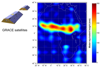
Water storage changes observed by GRACE, after Pfeffer 2013.
|
